
(2 pm. – promoted by ek hornbeck)
 Nearly a month ago, Yonah Freemark had a post at The Transport Politic entitled, Los Angeles’ Streetcar Plans: Too Duplicative of Existing Services?. He wrote:
Los Angeles has big hopes for its downtown, and, like most of the country’s major cities, it has seen significant population growth in the inner core over the past ten years. Now, to extend this renaissance, the city – also like many others – is planning a streetcar line that would traverse the district from north to south. Last month, it applied for $37.5 million in U.S. Department of Transportation TIGER grant dollars, which it hopes to supplement with local and private funds to complete an initial route of between 3 and 5 one-way track miles at a cost of between $106 and $138 million.
Despite the fact that planning for the L.A. streetcar goes back for more than a decade thanks to the work of a public-private local advocacy group, the city will have plenty of competition in its effort to win federal funds. Requests for the third round of TIGER funding outnumbered actual funding available by 27 to 1. With so many projects up for consideration, anything funded by Washington ought to be valuable. But L.A.’s project could benefit from significant improvement.
And then … well, join me over the fold.
And then Yonah makes this puzzling came:
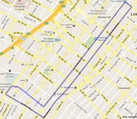
The fundamental problem with the proposed streetcar is that its service pattern would overlap that of other transit lines either funded or in service today. Though there are several corridors under consideration (a final route alignment will be selected in February 2012), each would run within the general north-south corridor between Broadway to the east and Figueroa to the west and Pico to the south and Union Station to the north.
But looking at the map … there isn’t any overlap at all. There are a number of regional rail corridors running to the general area, and even more planned to be completed … but none of them provide local area transport along Broadway. Say someone is near 2nd and Broadway and wants to get down to 7th and Broadway, or visa versa. This is exactly the type of “service pattern” provided by the streetcar line.
How exactly would that be duplicated? Catch the subway at Broadway/Spring to 7th / Metro Transit Center, and then walk four blocks east? Walk a block and a bit north and west to the Civic Center and then catch the Red line to Pershing square, and then walk two and a bit block south and east?
Even along the corridor where the Red Line and Blue Line both overlap the streetcar, the streetcar route is complementary to the two corridors ~ because you can hop on the streetcar to go a couple of blocks.
 Further on, Yonah asks:
Just how many similar transit lines does Los Angeles need running through its center city? Is a route that replicates existing transit necessary?
… but none of those routes are “similar” to the Streetcar. The service that is similar to the streetcar is the one that he ignores: the Dash which provides bus-shuttle style service in various parts of Downtown, with the Dash route D running a block and two to the east of the proposed Streetcar alignment.
But in terms of promoting infill development, including residential development for one car and no car households, a streetcar route is superior to a bus route, since the investment in the streetcar route provide a permanence that the bus route lacks. With the higher capital costs offset by lower operating costs and, in particular, lower operating cost per vehicle mile, the operator of a streetcar route has an incentive to offer higher frequency service than the operator of a shuttle bus route with the same total operating subsidy.
Indeed, by drawing new people into reliance on common carrier transport in the area, the streetcar is likely to act as a recruiter for Dash services extending through but beyond the streetcar district.
So the premise of the post, the argument that the streetcar represents a duplicate service, turns out to be an optical illusion: just because the lines on the map overlap does not mean that the service provided by a local transport service duplicates the service provides by a regional transport service. They are more likely to be complementary.
The Peril Of One-Way Streetcar Loops
This does not mean, however, that everything is rosy with this proposal. It does have a particular problem, which Yonah obseves:
The first is the one-way loop travel pattern of all of the proposed alignments. Rather than running in two directions on Broadway, which would appease those who feel that the east side of downtown is underserved by rail transit, all of the routes would run south on Broadway, only to turn around and run north on another street west of there. The result? People on Broadway would have to go south, then west, then north – just to get to the center of downtown. And people at L.A. Live, where a new football station is planned near Pico station, would have to go north, then east, then south – just to get to Broadway.
That is out-of-the-way thinking that does not address the travel needs of most people. Unsurprisingly, similar one-way transit loops in other cities have had difficulty attracting ridership. Though the transit agency predicts 7,000 to 11,000 daily riders on the line, one wonders what percentage of this group would simply be switching out of existing transit modes on parallel routes, to little benefit of anyone.
Now, as Poncho, one of the commentators at the site observes:
The problem is they try to spread out the LID funding and benefits of streetcar over as large an area as possible, so it becomes very diluted. They would be better to concentrate it on fewer streets where it has really strong benefits… really reinforce Broadway, the historic main street which was designed around a concentration of streetcar lines on a 2-way track. I cant stand having to catch the other direction of a transit line blocks away, its an unnecessary pain, confusing and many times is in a completely different neighborhood.
Now, the loop that goes one way on Broadway and the other way on Hill ~ that’s one thing. That’s separated by one block the short way … and if its going north on Broadway and south on Hill, its basically running on opposite sides of the same block, so you don’t even have to cross the street to catch the streetcar the opposite way.
But that big loop at the bottom: that’s the exact mess that is being describe by Poncho: the “preferred alignment” is running around a 4×4 block section. And the connection to the 7th / Metro Transit Section is on this section: someone from the bottom southeast corner of the route using it to get to 7th/MTC has to ride most of the way around the loop either on the way there or the way back.
Narrow One Way Loops Can Work … while a two way route on one street has a clearer identity, a loop running up one street and down the next parallel street can work nearly as well. And in this case, someone transferring onto the streetcar from either 2nd/Spring, the Civic Center, or Pershing Square and headed to Broadway could very well ride the streetcar around the “short” side of the loop and cut across the one short block to avoid being on the “long” side of the loop.
Big One Way Loops Can Work … they can be used to increase the frequency of a service that would otherwise be too low a frequency service as a two-way service. In order to work, they have to be reasonably short, so that a passenger is willing to take the loop “the short way” in one direction and “the long way” in the other direction.
Big One Way Loops At The End of Narrow One Way Loops Can Work … specifically, if the big one way loop is running through a residential area and only a small share of trips along the loop involve trips between different points on the big one way loop.
But This Narrow One Way Loop Widening Into A Big One Way Loop … there’s a serious risk that it won’t work … at least, not in the “Big Loop” section of the route. There’s a serious risk that the streetcar built along the lines of the “preferred alignment” above will be a useful streetcar route between 2nd and 7th and substantially underused between 7th and 11th.
Streetcars are walking amplifiers, working best when they replace a stretch of a too-long-to-walk trip into a trip on the streetcar with two easy-walking-distance trips on both ends. The preferred alignment is at risk of failing at that core service task for origins and destinations from 7th Street south.
Fixing the Broadway Streetcar Alignment
 The reason the route is messed up appears to be a basic flaw in thinking about the service. The route runs to 7th/MTC … and given the lay of the land, that is what creates this big open loop at the southern end.
But why should it go to 7th / Metro Transit Center? It is true that this is an interconnect between all of the regional lines running through this area ~ the Red Line, the Blue Line, the subway (dashed Green line), the Bus Rapid Transit line (the light gray line on the map). But someone on Broadway will want to get to one of these line in particular … and someone on one of these lines that wants to get to Broadway will want to connect to Broadway. And along the northern route, the streetcar route already connects to all of these routes.
And meanwhile, the 7th/MTC connection is a badly flawed connection, since using it either outbound from Broadway or inbound to Broadway basically means riding around the entire streetcar route … so if you are heading north of 7th street, you are much better off using 2nd/Spring, Civic, or Pershing Square as your connection.
As a complement, it makes much more sense connecting to lines coming in from the South at Pico, which also allows for a much narrower one-way loop using Pico and 12th. Now, as drawn, these ma be running the wrong way, so if the corridor is (at least initially) running mixed with traffic, then the actual alignment may run from Broadway to 12th and then loop around from Pico to Hill … but in any event, it becomes possible to use it as a two-way route running along opposite sides of the same block.
Finishing the Route
Ideally, the route would run to Union Station. However, an alignment that gets there might require some thinking outside of the box.
One thing I note is that the “Silver Line’ ~ the BRT corridor ~ runs from the top edge of the preferred streetcar alignment to Union Station.
And, of course, these streetcars are intended to run mixed with traffic ~ so unlike many rail vehicles, it would not require any substantial modification to either the streetcars or the BRT buses to allow them to share a corridor.
So one extension of the streetcar route to explore would be putting the streetcar track into the BRT corridor, and using the BRT corridor to get up to Union Station. From there, the streetcar line would be connected to far more than regional transport routes: it would be connected directly to existing intercity rail, to the proposed California High Speed Rail, and connected via the airport shuttle to the airport.
1 comment
Author